House History Research
Researching the history of your home or building is not hard, but can be a time intensive process. The sources are scattered across municipal, state, and federal agencies as well as your local and state archives. Maps of many varieties, county histories, building records, city directories, and property inventories all provide different facets of the story of your home and neighborhood. Photographs may exist in real estate or tax assessment collections. Blueprints and other building plans, however, were not kept by local municipalities; rarely, you may find that they have been passed from owner to owner or hidden in rafters of the home.
Find out when your home was built
County Property Assessment
- Ingham County Assessor
- Eaton County Assessor
- Jackson County Assessor
- Clinton County Assessor
- Shiawassee County Assessor
Search by address, owner, or parcel number. Searching by a house number range or just a street name will bring back a range to select from, which may be more effective than entering a specific address.
Some pages allow viewing in a Geographic Information System (GIS), and may include recent property photos. In the Summary Information section, a construction date is usually listed. However, use caution with the built date of older homes. Assessor information (built date) sometimes corresponds only with when taxes began being paid to the current municipality. Additionally, early records may have been lost or destroyed and an approximation was made on the date.
County Register of Deeds
- Ingham County Register of Deeds
- Eaton County Register of Deeds
- Jackson County Register of Deeds
- Clinton County Register of Deeds
- Shiawassee County Register of Deeds
A visit to the Register of Deeds office should be made to obtain a Chain of Title and other information. Plan at least an hour of searching time, and note that there may be limits to photocopying or scanning. You may also not be permitted to bring personal devices such as a smartphone or tablet into the building or office. Some material may be available online, but will not necessarily go back to the earliest platting of land before a home was built, or its earliest ownership. Tracing the history of your property through the Register not only will show when the Deed was created, but will provide additional information about owners and the land.
Maps and other Land Research Resources
Local County, Township, Village & City maps
- 1847 Map of the Town of Michigan, in the County of Ingham (From Michigan State University Map Library)
- 1859 Topographical Map of Ingham County
(From the Library of Congress) - 1874 County atlas of Ingham, Michigan (From HathiTrust)
- 1895 Standard Atlas of Ingham County, Michigan
- 1914 Chadwick Farm Atlas of Ingham County (From Michigan State University Map Library)
- Sanborn Fire Insurance Maps, Lansing, Michigan (From the Library of Congress) Available for years 1885, 1892, 1898, 1906, 1913, 1926, 1953.*
- 1873 Atlas of Clinton County, Michigan
- 1896 Standard Atlas of Clinton County, Michigan
- 1915 Standard atlas of Clinton County, Michigan
- 1873 Atlas of Eaton County, Michigan
- 1894 Plat Book of Jackson County
*The Archives of Michigan holds an 1868 Sanborn Fire Insurance Map for Lansing, the earliest known version for this area.
Unless otherwise noted the above maps are provided by the Michigan County Histories and Atlases Project.
Additional Maps and Land Resources
- Federal Survey Plats and Land Patent Search
(At the U.S. Department of the Interior, Bureau of Land Management) - Michigan Statewide Search for Subdivision Plats
Use the Subdivision name found in your assessor records to search this resource, which provides access to printable PDF images of the plats and related information. Not compatible with all web browsers. - Michigan Rural Property Inventories
(PDF; At the Archives of Michigan) - Michigan State University Libraries Scanned Maps Collection
Downloadable, high-resolution early maps of Michigan - Historic Preservation in Lansing, Michigan
Home Research Resources
- Antique Home Style Designs
- American Architecture of the 20th Century
- Timeline of Architectural Styles in America circa 1600-1960s
Resources in the Local History Center
A Note on Street Names
Whenever possible, we have listed a street name and address for property records in Local History Online. We try to keep street name conventions in line with USPS guidelines, but we do not abbreviate words like North/South/East/West or Street/Road/Boulevard in our subject headings and search terms. One easy way to find anything for a particular address is to just enter the street name as a keyword. For example, to find records for a house at 123 W. Saginaw St., you can just enter "Saginaw" (without quotes) and browse all of the results. You can also search by house or business address number and browse results.
Real Estate Collections
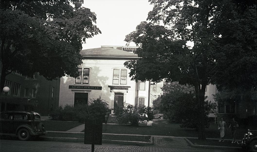
Our most significant resource for property research is the Stebbins Real Estate Collection. The Stebbins family founded their real estate company, Advance Realty, in the mid 1920s in Lansing, and operated it into the 1970s. Company leaders were heavily involved in the Greater Lansing Board of Realtors over the years. This collection contains nearly 400 boxes of material organized by street address, covering greater Lansing and Ingham County. Odds are if a property was on the market during Advance's active years, there will be a file on it. Exterior photographs, negatives, listing information, classified ad clippings, and more for both residential and commercial properties may be found in each file. Unfortunately, interior photographs are not part of the collection.
Due to the quantity and mix of materials in the collection, it has not been digitized in its entirety. Funding from the Helen J. Earley estate gift supported a major conservation project in 2017-2018, and the Library of Michigan awarded CADL a Library Services and Technology Award grant in 2024-2025 to digitize the first portion of the collection. Search for your street name in Local History Online, or view the Stebbins Real Estate Collection online record to see if your location might be included. Materials will be scanned on demand if not already available online.
![]()

We have a complimentary collection to Stebbins, the Belon Real Estate Collection, which contains similar material. The agency operated from 1952 to 1970. Files contain standardized 4" x 6" listing cards, often with exterior photographs, for greater Lansing and Ingham County. This collection has been fully digitized and is available in Local History Online, organized by street name.
Construction Permits and Licenses
For property in the City of Lansing, it may be possible to determine if your house was moved, or if certain types of renovation or construction took place and when. Two collections, each with a wide variety of permit and license types recorded, are held by Local History and have been digitized for public access. The date range is limited in both of these collections and there are often spelling and other inaccuracies. Content is hand-written and has not been transcribed.
Other Property Resources
The Lansing City Assessor Photograph Collection is another source for residential property photographs. This collection is limited to property in the city of Lansing, and many neighborhoods are not included. Individual records identified by street address for approximately 17,000 images in the collection are available in Local History Online.
Aerial photographs can be another useful source of information in property research. We have three sets, which focus on the City of Lansing: 1948, 1966-1970, and 1978. All of these were taken for the City of Lansing by the Abrams Aerial Survey Corporation. The 1948 and 1966-1970 sets have been digitized and are available for use within in the library; the 1978 set has not but the original photos are also accessible in the library. An index to the 1966-1970 aerials is available online.
City Directories are another excellent source for property research, especially if you are looking to add a biographical element to the history of a structure. Six of our earliest directories are available in PDF form:
- 1867 (Smith)
- 1873 (Brown)
- 1878 (Pryor & Co.) [View the Mudge 1878 directory in full text on Hathi Trust here.]
- 1883 (Polk)
- 1894 (Chilson and McKinley)
- 1904 (Chilson and McKinley)
Download our City Directories handout for more Lansing-related information about using these books in property and other local history research.
Note that address numbers prior to 1906 are inconsistent and have to be deciphered individually; there does not seem to be a comprehensive cross-reference key. The 1868 Sanborn fire insurance map shows the street numbers for Washington Avenue only. Later Sanborn maps (1885, 1892, 1898, 1906, 1913, and 1926) show the second and third numbering systems for some buildings. The 1913 maps in particular use dual numbering for many streets, effectively serving as a cross reference. The Sanborn Maps are available from the Library of Congress, with the exception of the earliest (1868) which is held by the Archives of Michigan. By using the Sanborn maps, other maps, atlases, plat books, property tax records, and other city directories, you have a chance of locating the address you are looking for.
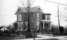
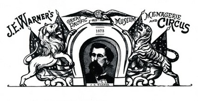
This home was built in 1875 by Joseph Warner, one-time mayor of Lansing and a circus owner who maintained a menagerie on the then 80-acre property. Among the animals he kept were lions, bears, a tiger, a jaguar, several monkeys and a hippopotamus.
Location
2175 University Park Drive
Okemos, MI 48864
517-367-6313
localhistory@cadl.org